A135 road
Appearance
This article needs additional citations for verification. (December 2020) |
| A135 | |
|---|---|
 | |
| Route information | |
| Length | 3.7 mi (6.0 km) |
| Major junctions | |
| North end | Stockton-on-Tees |
| South end | Yarm |
| Location | |
| Country | United Kingdom |
| Road network | |
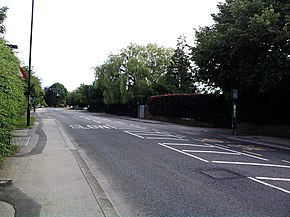
The A135 [1] is a road in England, running from Stockton-on-Tees through Eaglescliffe to Yarm on the A67, on the boundary with the River Tees. It is also known as Yarm Road, and was the A19 before the dual carriageway was built. In the 19th century, a stagecoach raced along Yarm Road against Locomotion Number One which ran alongside on the Stockton to Darlington railway line. There is no record as to which won the race.
| 2000 | 2001 | 2002 | 2003 | 2004 | 2005 | |
|---|---|---|---|---|---|---|
| Pedal Cycles | 158 | 151 | 157 | 141 | 114 | 96 |
| Motorcycles and Mopeds | 150 | 156 | 158 | 177 | 156 | 158 |
| Cars | 18,666 | 19,039 | 19,001 | 18,735 | 18,773 | 18,304 |
| Buses and Coaches | 437 | 445 | 455 | 406 | 378 | 372 |
| Light Goods Vehicles | 2,047 | 2,039 | 2,043 | 2,227 | 2,207 | 2,264 |
| Two-axle Rigid HGVs | 214 | 210 | 202 | 217 | 218 | 209 |
| Three-axle Rigid HGVs | 15 | 17 | 17 | 19 | 20 | 19 |
| Four-axle Rigid HGVs | 3 | 3 | 3 | 3 | 4 | 4 |
| Three-axle Articulated HGVs | 45 | 40 | 36 | 34 | 33 | 29 |
| Five-axle Articulated HGVs | 52 | 45 | 39 | 35 | 30 | 26 |
| Six-axle Articulated HGVs | 13 | 15 | 17 | 19 | 20 | 22 |
| All HGVs | 342 | 330 | 314 | 327 | 325 | 309 |
| All motor vehicles | 21,642 | 22,009 | 21,971 | 21,872 | 21,839 | 21,407 |
| 2000 | 2001 | 2002 | 2003 | 2004 | 2005 | |
|---|---|---|---|---|---|---|
| Pedal Cycles | 88 | 84 | 87 | 78 | 63 | 53 |
| Motorcycles and Mopeds | 77 | 80 | 81 | 91 | 80 | 81 |
| Cars | 8,919 | 9,097 | 9,079 | 8,952 | 8,970 | 8,746 |
| Buses and Coaches | 211 | 215 | 220 | 196 | 183 | 180 |
| Light Goods Vehicles | 971 | 967 | 969 | 1,056 | 1,047 | 1,074 |
| Two-axle Rigid HGVs | 105 | 103 | 99 | 106 | 107 | 102 |
| Three-axle Rigid HGVs | 9 | 10 | 10 | 11 | 12 | 11 |
| Four-axle Rigid HGVs | 1 | 1 | 1 | 1 | 1 | 1 |
| Three-axle Articulated HGVs | 19 | 17 | 15 | 14 | 14 | 12 |
| Five-axle Articulated HGVs | 24 | 21 | 18 | 16 | 14 | 12 |
| Six-axle Articulated HGVs | 4 | 5 | 6 | 7 | 7 | 8 |
| All HGVs | 168 | 157 | 149 | 155 | 155 | 146 |
| All motor vehicles | 10,340 | 10,516 | 10,498 | 10,450 | 10,435 | 10,227 |
| 2000 | 2001 | 2002 | 2003 | 2004 | 2005 | |
|---|---|---|---|---|---|---|
| Pedal Cycles | 70 | 67 | 70 | 63 | 51 | 43 |
| Motorcycles and Mopeds | 73 | 76 | 77 | 86 | 76 | 77 |
| Cars | 9,747 | 9,942 | 9,922 | 9,783 | 9,803 | 9,558 |
| Buses and Coaches | 226 | 230 | 235 | 210 | 195 | 192 |
| Light Goods Vehicles | 1,076 | 1,072 | 1,074 | 1,171 | 1,160 | 1,190 |
| Two-axle Rigid HGVs | 109 | 107 | 103 | 111 | 111 | 107 |
| Three-axle Rigid HGVs | 6 | 7 | 7 | 8 | 8 | 8 |
| Four-axle Rigid HGVs | 2 | 2 | 2 | 2 | 3 | 3 |
| Three-axle Articulated HGVs | 26 | 23 | 21 | 20 | 19 | 17 |
| Five-axle Articulated HGVs | 28 | 24 | 21 | 19 | 16 | 14 |
| Six-axle Articulated HGVs | 9 | 10 | 11 | 12 | 13 | 14 |
| All HGVs | 180 | 173 | 165 | 172 | 170 | 163 |
| All motor vehicles | 11,302 | 11,493 | 11,473 | 11,422 | 11,404 | 11,180 |
See also
[edit]References
[edit]- ^ "Google Map of A135 route". Retrieved 20 September 2007.
- ^ a b c "Traffic statistics on the A135, Stockton-on-Tees, Stockton-on-Tees | NZ440186". roadtrafficstats.uk. Retrieved 14 November 2023.
54°32′13″N 1°20′29″W / 54.53687°N 1.34145°W

